TEMA

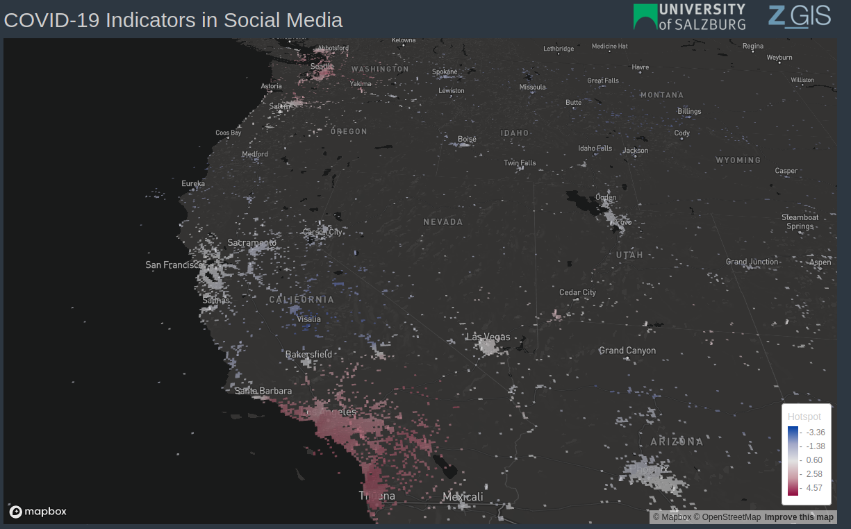
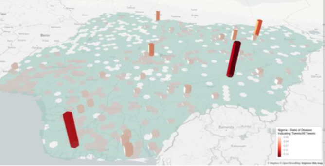
TEMA TEMA stands for „Trusted Extremely Precise Mapping and Prediction for Emergency Management”. It is a four year long project that was funded by the European Union through its Horizon Europe. The main objectives are improving disaster management by using new digital technologies, accelerating extreme data analytics and increasing its trustworthiness, and improving the [...]

TEMA2024-03-01T10:15:59+01:00

DigitalInnovationLayer

DigitalInnovationLayer Traditional economic geography analyses are usually based on patent analyses or qualitative expert interviews. For some years now, however, digital data sources have increasingly been used to quantify and evaluate economic activities. In particular, the analysis of company websites and social media should be mentioned here. We are working with two partners to [...]

DigitalInnovationLayer2024-03-01T10:11:57+01:00

COVID-19

COVID-19 - Spatial and Temporal Epidemiology   Geo-social Media Analytics for Monitoring the Spatio-temporal Spread of COVID-19     B Background The epidemiology of airborne infectious diseases such as the coronavirus SARS-CoV-2 is an inherently spatiotemporal phenomenon. Moving through time and space, a disease can be tracked by interpreting geographical data such as medical incidence [...]

COVID-192023-03-26T18:08:32+02:00

ESSEM

ESSEM   Emotion Sensing for (e-) bike safety and comfort in mobility   B Background Bicycle mobility is becoming increasingly relevant in the mobility system and has gained additional importance due to the Corona pandemic and the possibilities of the pedelec. This is reflected not least in rapidly rising sales figures, which could result in [...]

ESSEM2023-03-26T18:08:41+02:00

GeoSHARING

GeoSHARING   Analysing Geo-social Media using Geospatial Machine Learning to Support Humanitarian Decision-making     B Background User-generated geo-data from sources like social media, micro blogs, or mobile networks carry valuable information (spatial, temporal, semantic), which is able to support decision-making in humanitarian action. However, these data are methodologically challenging to analyse because of various [...]

GeoSHARING2023-03-26T18:09:09+02:00

AIFER – Artificial Intelligence for Emergency Response

AIFER - Artificial Intelligence for Emergency Response Artificial intelligence for analysis and fusion of remote sensing and internet data for decision support in emergency management B Background Disaster events and major damage situations such as floods, forest fires, extreme snow conditions or storms are increasingly presenting disaster control with major challenges in terms of [...]

AIFER – Artificial Intelligence for Emergency Response2024-03-01T10:38:15+01:00

Spatio-temporal Epidemiology

Spatio-temporal epidemiology of emerging viruses   Leveraging crowdsourced data and occurrence data to improve early disease detection systems     B Background The field of Spatial Epidemiology has emerged based on the broad agreement that maps for infectious diseases of global importance are important for addressing the transmission potential, limits of transmission and underlying risk [...]

Spatio-temporal Epidemiology2023-03-26T18:09:25+02:00
Go to Top